Tokyo Stroll Supplement: Sawara
This page is a supplement page for the book Tokyo Stroll for day trips from Tokyo to the Sawara area in Chiba-ken.
For information on Tokyo Stroll and this web supplement see Tokyo Stroll Supplement home page
For users of the Organic Maps, Maps.Me and Google Maps apps the items below have bookmarks you can import into those apps to make navigation easier.
Instructions and links are on the Viewing Locations in Organic Maps, Maps.Me, Google Maps, or Google Earth page.
Some entries on this page may include a note that says "Description to be added soon ." These entries are for items I felt should be listed even if the description is not ready to assist those who wish to plan a trip. When possible I included a link to an official web page, I suggest also doing web searchs for more information.
Sawara (佐原)
Sawara is part of Katori-shi / Katori City (香取市) a town in Chiba-ken on the Tone river, the Tonegawa, formed in 2006 by the merger of Sawara (佐原) and other local communities. Long a rice growing area, during the Edo Period the Sawara area also became a major regional transit center for the shipping of rice, sake, and other goods to Edo through various waterways. The area also became a popular place to visit in the Edo Period with access to famous shrines and temples by way of the canals and local roadways. Sawara is famous for festivals in the summer and fall, the biggest being in July and October.
WEB Guide book: https://www.city.katori.lg.jp/smph/sightseeing/multilingual/en/guidebook.html
ACCESS: Getting to the Sawara area of Katori from Tokyo.
From Ueno by train:
Take the Keisei Honsen train at Keisei Ueno Station to the Keisei Narita Station, then walk to the JR Narita Station and take the JR Narita-sen Line to Sawara Station.
From Tokyo Station by Bus:
Yaesu Exit Chiba Kotsu Highway Bus, Choshi-Tokyo Route. Eleven buses a day from 8:50 am to 10:20 pm.
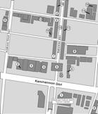
Baba Honten Shuzō (馬場本店酒造)
Originally a kōji shop founded in the 18th century, the family began making sake in 1842 which means this is one of the oldest sake breweries in the area. Today they sell sake, mirin, and shōchū.
ACCESS: A short walk from the Inō Tadataka Museum and the Ōnogawa.
WEB: https://babahonten.com
Inō Tadataka Museum (伊能忠敬記念館)
When he was 17 Inō Tadataka (1745-1818) married into a well to do family that had a sake brewery and rice dealership. As the adopted heir he took charge of the business and family, as the 10th head, until he retired when he was 50 turning over the headship to his eldest son. He then moved to Fukagawa in Edo where he studied mathematics, geography and Western astronomy for 5 years. With that knowledge he began a series of journeys to create the first complete map of the coastal areas of Japan based on actual measurements by him and those he supervised. The museum has exhibits on his life and the instruments he used as a cartographer.
The famous manga creator Taniguchi Jirō wrote a work based on Inō's retirement years entitled Furari which is available in an English translation.
WEB: https://www.city.katori.lg.jp/smph/sightseeing/museum/index.html
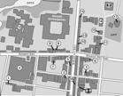
Katori Shrine / Katori Jingū (香取神宮)
The Hitachi no Kuni Fudoki states this major shrine was founded in 643 BC in the 18th year of Emperor Jimmu's reign. Katori-jingū is the head shrine of some 400 Katori shrines found mainly in the Kantō region but also in some other parts of Japan. In the Edo Period Katori-jingū was rebuilt in 1607, and again in 1700. The current honden, with its cypress bark thatched roof, dates from 1700 and in 1977 was designated as Important Cultural Property. The shrine's red Rōmon gate dates from the 18th century and the calligraphy on the name plaque is by Admiral Tōgō Heihachirō. In 1983 the Rōmon was designated an Important Cultural Property. The kami enshrined here is Futsunushi-no-Ōkami who is associated with swords and lightening. The sword master Iizasa Chōisai Ienao, founder of the Tenshin Shōden Katori Shintō-ryū, meditated here and it is said received secret techniques from the kami. The grounds are large with various sub-shrines and other buildings.
EVENTS: The shrine festival is on April 14, every three years a three day Grand Festival is held.
WEB: https://katori-jingu.or.jp/
Located near the Onogawa (小野川) and a short walk from the Inō Tadataka Museum this restaurant has been in business since 1782. The current building dates from 1892, the glass door is from 1902. Koboriya is known for serving cold kuro-soba, soba that is black due to the use of powdered fresh konbu seaweed from Hokkaidō in the cooking. They also serve warm soba dishes, tempura, and other dishes.
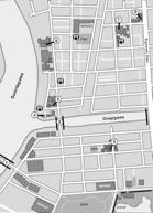
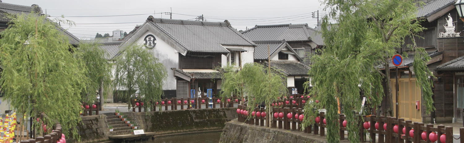
Sawara Machinami / Sawara Old Town (佐原町並み)
A historical district near the Onogawa (小野川) with many traditional buildings. The Japanese Agency for Cultural Affairs designated the area an Important Preservation District for Groups of Traditional Buildings. The buildings along the Ōnogawa river are today a tourist draw with old merchant houses, restaurants, and museums. Most of the items on this web page are within that district.
Suigō Sawara Ayame Park (水郷佐原あやめパーク)
An aquatic botanical garden famous for some one and a half million irises in hundreds of varieties and over 300 varieties of lotus. The best time to view the irises is May to June, June is also when the Iris Festival takes place. The lotus are at their peak in July and August. The admission charge to the park varies with the seasons.
ACCESS: The park is about 20 minutes from Sawara Station. During the festival there are shuttle busses, during the COVID pandemic the busses are not available.
WEB: https://ayamepark.jp/
Suigo Sawara Float Hall / Suigō Sawara Dashi Kaikan (水郷佐原山車会館)
A small museum displaying two of the massive floats used in the Sawara Grand Festival parades as well as many related items. The summer festival held in July is called the "Honjuku Yasaka Shrine's Festival", and the fall one held in October the "Shinjuku Suwa Shrine's Festival." The floats are made of beautifully carved zelkova wood, embroidered fabrics, and have large statues of legendary figures.
WEB: https://www.city.katori.lg.jp/sightseeing/sawaradashikaikan/index.html
Tone River / Tonegawa (利根川)
The Tonegawa is the second longest river in Japan. It was once highly prone to flooding and emptied into what is now Tokyo Bay along the path of the Edogawa. Under the Tokugawa shōguns projects were undertaken to direct much of the floodwaters eastward to empty into the Pacific Ocean to reduce flooding in Edo. In the Meiji Period there began a series of further changes to the flow to fully divert the river to the Pacific, such management of the river continues until today.
Commonly referred to as the Jājā Bashi. This small bridge is located near the Inō Tadataka Museum. In the Edo Period an irrigation canal ran near here and drained under the bridge. Every 30 minutes a waterfall drains from the bridge creating a "jājā" sound. The Ministry of the Environment has listed this as one of the Hundred Soundscapes of Japan.
Back to the Tokyo Stroll Supplement home page - Privacy Notice - Back to Gilles' home page
Created February 14, 2023 | Content last updated Julu 30, 2025