Tokyo Stroll Supplement: Chichijima
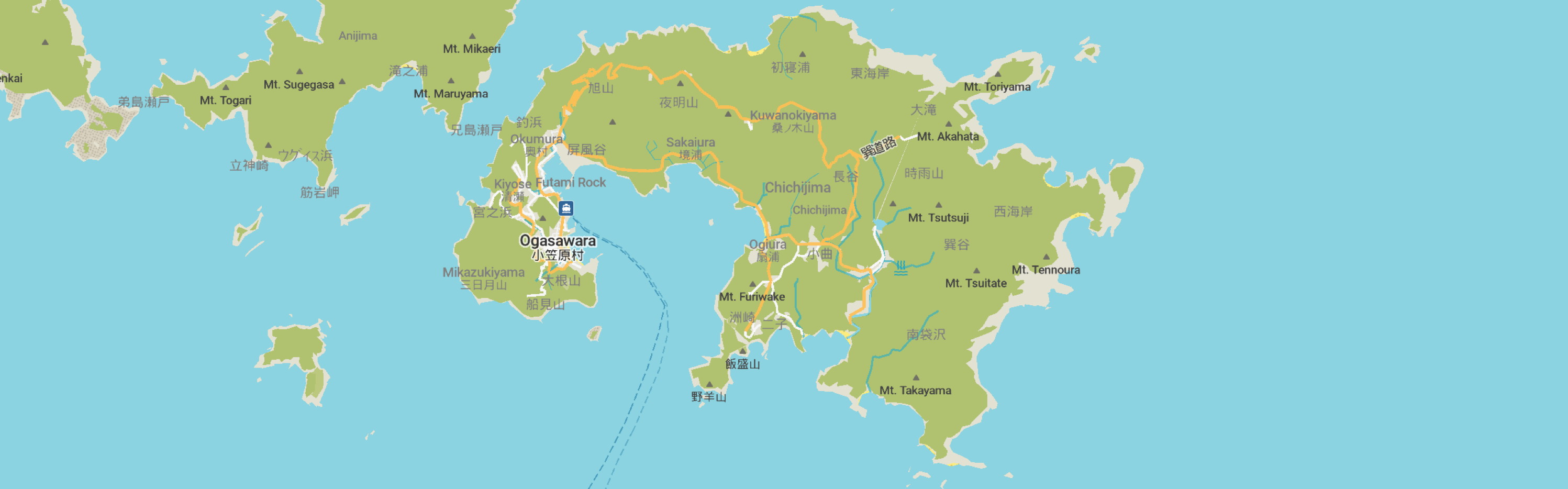
This page is for locations on Chichijima Island in the village of Ogasawara Mura of the Ogasawara Subprefecture of Tokyo. This island is not part of my book Tokyo Stroll.
For information on Tokyo Stroll and this web supplement see Tokyo Stroll Supplement home page
For users of the Organic Maps, Maps.Me and Google Maps apps the items below have bookmarks you can import into those apps to make navigation easier.
Instructions and links are on the Viewing Locations in Organic Maps, Maps.Me, Google Maps, or Google Earth page.
Some entries on this page may include a note that says "Description to be added soon ." These entries are for items I felt should be listed even if the description is not ready to assist those who wish to plan a trip. When possible I included a link to an official web page, I suggest also doing web searchs for more information.
Chichijima (父島)
Official pages for each of the towns and villages of Tokyo will have sections of interest to visitors. These will likely be labeled as dealing with culture, tourism, or events.
Ogasawara Mura official site for Chichijima: https://en.vill.ogasawara.tokyo.jp/chichijima/
Chichijima web site: https://www.ogasawaramura.com/en/
NOTE: Given the difficulty of adding many specific location bookmarks to my bookmark files some places on the island may not be listed. Check the local website for more information.
ACCESS:
From Tokyo Takeshiba Pier:
Ferry, trip lasts about 25 hours and the number of trips varies from every few days or much less depending on the season.
HISTORY:
This island was long uninhabited, some Micronesian artifacts have been found on other islands in the Ogasawara Island chain but none on Chichijima.
The earliest known records of a visit to the island is from 1639 when a Dutch ship in search of fabled islands came across it and other islands in the chain. Then in 1670 a Japanese ship blown off course shipwrecked on Hahajima, the crew made their way to Chichijima and from there sailed their way back to Honshū where they reported what they found. The shōgunate then gave special permission for an ocean capable ship, such were forbidden at the time, to be built to explore the islands. After being used as a merchant vessel for a few years a secret mission was ordered in 1674 to find and explore the islands. After a few failed attempts the mission reached them in 1675. They then explored, established a Shintō shrine, and mapped the islands returning with soil samples, animals, and plants. The islands were then placed under the control of Izu Province, the ship broken up, and the islands remained isolated and uninhabited until 1830.
The islands were next visited in the late 1820s by British and Russian ships. A British captain claimed the islands for his country in 1828, later the British would recognize Japanese sovereignty. In 1830 a settlement was established by people from the kingdom of Hawaii. The settlement at first was mainly Hawaiian with some Europeans and Americans, eventually more Pacific Islanders, Americans and Europeans joined the settlement. In 1853 Commodore Matthew C. Perry's expedition to Japan stayed there for a few days, Perry then claimed the islands for the US. In 1862 official representatives of the Tokugawa Shōgunate went to the island to reestablish Japanese sovereignty, and recognized the government of the settlement as official. New settlers, from Japan this time shifted the demographics of the island to mainly Japanese, the non-Japanese settlers came to be called Ōbeikei. Over time an interesting dialect, Bonin English, emerged on the islands which consisted of the mix of Japanese, English and Hawaiian. In 1880 the administration of the islands was transferred to Tokyo.
During WWII Chichijima a few thousand Japanese military personel were stationed on the island as a supply and communication base. In 1944 all the civilians were evacuated to Honshū leaving the island in the hands of the military.
After the war occupation forces took over the Japanese base. SCAP only allowed 129 Ōbeikei to return to the island. The island was returned to Japanese control in 1968 and the Ōbeikei were given the option to become US or Japanese citizens. Some moved to the US but maintain relations, even running businesses during the tourist season. Today about 200 Ōbeikei and American identified residents are on the island.
There are a variety of shops and places to eat on the island.
Today ecotourism, fishing, and farming are the main sources of income on the island. There is also local salt production, coffee, and rum.
The name of the island translates as "Father Island."
POPULATION: The population in 2021 was 2,120
DISTANCE FROM TOKYO: Located 1,000 km south of Tokyo center in the Ogasawara Islands.
ACCOMODATIONS: There is a variety of accomodations in various parts of the island. It is advisable to book in advance.
LOCAL TRANSIT: Busses, as well as car, motor bikes, and bicycle rental are options.
Chihiroiwa (千尋岩)
Description to be added soon
Hinkō Maru (濱江丸)
Description to be added soon
Minamijima (南島)
Description to be added soon
Ogasawara Visitor Center / Ogasawara bijitāsentā (小笠原ビジターセンター)
Description to be added soon
WEB: https://www.ogasawaramura.com/visitorcenter/
Back to the Tokyo Stroll Supplement home page - Privacy Notice - Back to Gilles' home page
Created September 24, 2026 | Content last updated September 26, 2026